42 Traverse

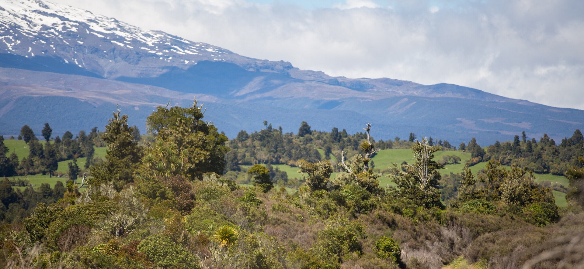
This is a classic MTB track serving up spectacular volcanic scenery and beautiful native bush on the fringe of Tongariro National Park. Named after the old State Forest 42 it traverses, this wilderness ride follows old logging routes through a spectacular valley, and amidst regenerating native bush with epic views of the volcanoes.
Thrilling downhills, energy-sapping climbs and some tricky rutted sections and stream crossings combine to make this a challenging but satisfying adventure for experienced mountain bikers. Note this trail also forms part of the Te Araroa trail.
Highlights
- crazy volcanic landscape
- long, fun downhills
- babbling rivers
- beautiful native bush
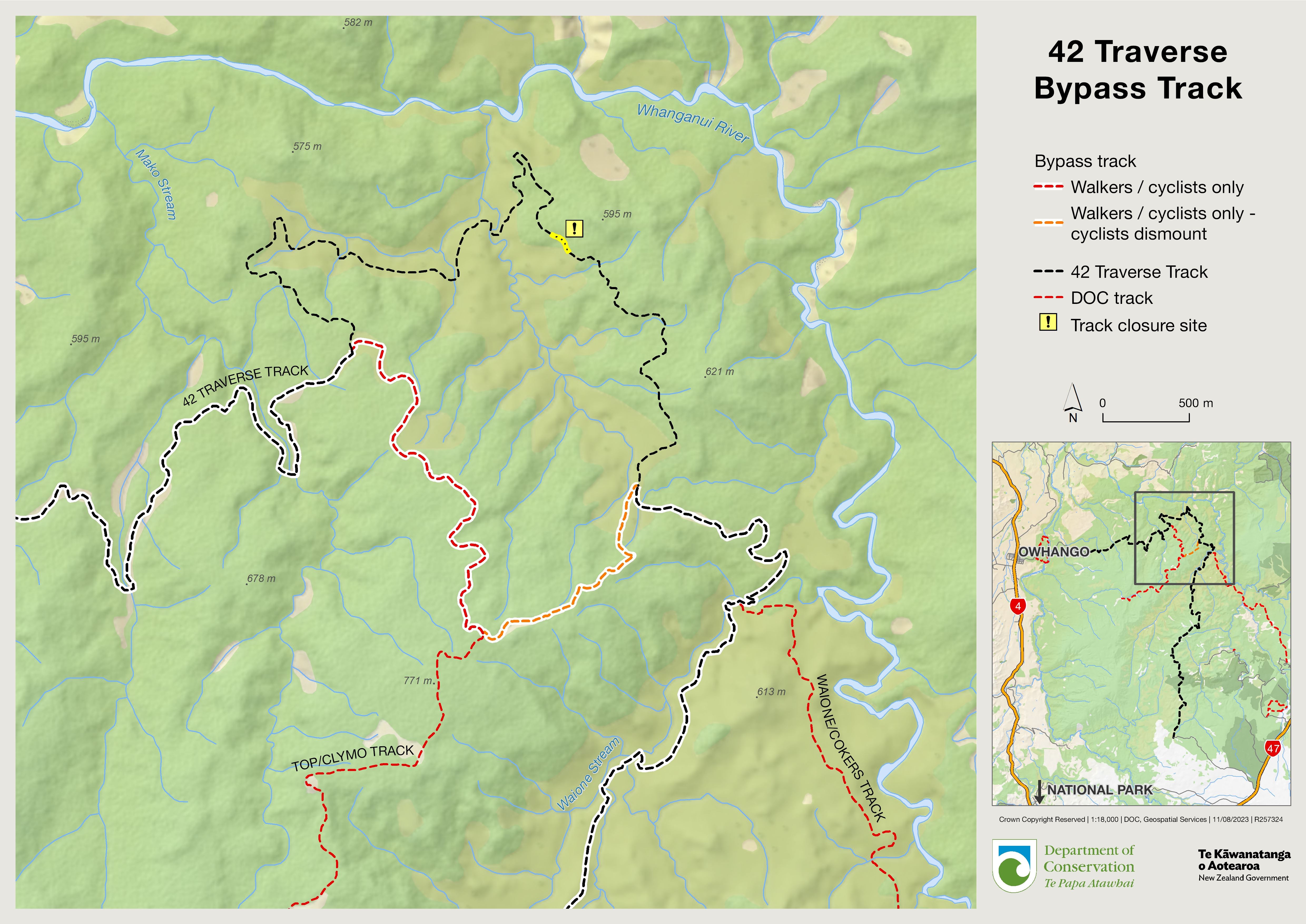
Bypass in place due to moving landslip
See information on alternative route. Noting that the bypass track is slippery and steep. DOC recommends cyclists dismount through this section. It is also recommended you carry navigation equipment as signage has been prone to vandalism.


Alternative route in place
There is an alternative route in place of a section which remains closed due to a moving landslip. Link below for map.
Riding the Trail
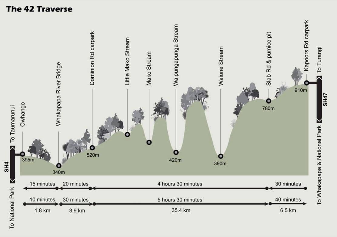
The 42 Traverse is an undulating ride with plenty of challenging downhills and significant uphills. However, it’s best ridden from the SH47 end, finishing in Owhango, as it’s an overall descent of around 520m in this direction.
Local shuttles will drop you off at the start – Kapoors Road car park. If you have your own car, there’s secure parking in Owhango or arrange for a shuttle to pick you up from the end after some well-earned refreshments in the Owhango Hotel.
From the Kapoors Road car park, the trail dips into regenerating native forest rich in birdlife. After a gentle 7km descent down a gravel track to a large clearing, the trail follows the main ridge northwards past highpoint 831m (marked on topo maps). At the next small clearing (Kiwi Clearing) there are some wonderful views back towards Mt Ruapehu.
Keep an eye out for signs and be careful not to take a wrong turn over the next few, undulating kilometres as there are plenty of opportunities to get lost!
Around 15km into the ride, around 1km after highpoint 793, is a track to the right of the main trail. Follow this to the Echo Canyon lookout for the best views on the whole ride and great place to stop and refuel.
Next up is the long, grin-inducing downhill to the Waione Stream. Be wary of slippery patches of clay in the wet that can turn that grin into a grimace in an instant.
Cross the stream, the first of four, at the main ford a little further downstream from where you first encounter it. If the waters are high you may have to carry your bike. In fact, riders with an aversion to getting wet feet might want to cross the 42 Traverse off their bucket list!
Waione Stream is around the halfway point, with the second part of the ride undulating in and out of the pretty forested valleys, home to the endangered North Island brown kiwi. Follow the signs and turn right on to the Pony Club Track before climbing for a rewarding view of the headwaters of the Whanganui River.
Keep on the main trail, known as Dominion Road, past the highpoint of Te Kaha (597m) and Waterfall Bridge, before freewheeling through stunning native bush down to the Whakapapa River bridge. This is the normal shuttle pick-up point for riders who don’t want to finish with the gentle 2km climb to Owhango on SH4. At the bridge, there are toilets, a picnic area and a very pretty, if frigid, swimming hole.
M2SNZ Route Notes:
The 42 Traverse is maintained by the Department of Conservation. Open over Summer (1 Dec - 30 April) to 4WD enthusiasts it can be a rough ride at times - so do check with the locals to discover the current state of play.


Need to Know
This is a Grade 3 (intermediate) trail but really is best suited to riders with good skills and a high-level of fitness.
Starting from the Kapoors Road end, it’s downhill overall, but there are plenty of challenging climbs in the mix too. Between December and May, riders also need to be prepared to encounter 4WD vehicles that are also allowed on the track. Horses and trail bikes may also be present.
The trail is made up of a combination of mainly gravel road and 4WD track with surfaces switching between gravel, between gravel, sand, rock and mud. Much of it can be rough and rutted, and subject to slips, especially in winter.
In wet conditions, the trail becomes a much harder and longer undertaking. Extra care should be taken around the streams, which can rise dramatically after heavy rain, with the Waione Stream sometimes becoming impassable.
The track is on the fringe of mountainous Tongariro National Park. The weather can change quickly and it can get cold at any time of the year and be blanketed in snow during winter. It is vital to check the Tongariro National Park weather forecast and contact the DOC Whakapapa Visitor Centre or local operators for the latest conditions.
A well-maintained, high-quality mountain bike with good tyres is essential for this ride
Riders should be well-equipped and capable of looking after themselves in this remote backcountry environment. Riders should take warm, wet-weather gear in all but the finest conditions.
A repair kit, spare tubes and a first-aid kit should be carried. In addition, at least one person in the group should possess good bike repair skills.
The forest is a labyrinth of old logging roads and trails, and it’s very easy to get lost. There are trails before and after junctions, but are easy to miss. Riders should take a map and compass or GPS, and consider taking a personal locator beacon (PLB).
There is no food and water on the trail, so riders should carry their own supplies.
Shuttle transport is readily available but must be booked in advance.
There is no cellphone reception on this trail.
There are public toilets in National Park Village, and at the Owhango end next to the bridge at Ohinetonga Scenic Reserve.
Need help booking?
Our local i-Site can help you plan and book your trip.
OR Book directly with Trail Partners and discover the Mountains to Sea's cycle trail journeys for yourself.


NGĀ ARA TŪHONO TRUST 50232641
NZBN: 9429052786808