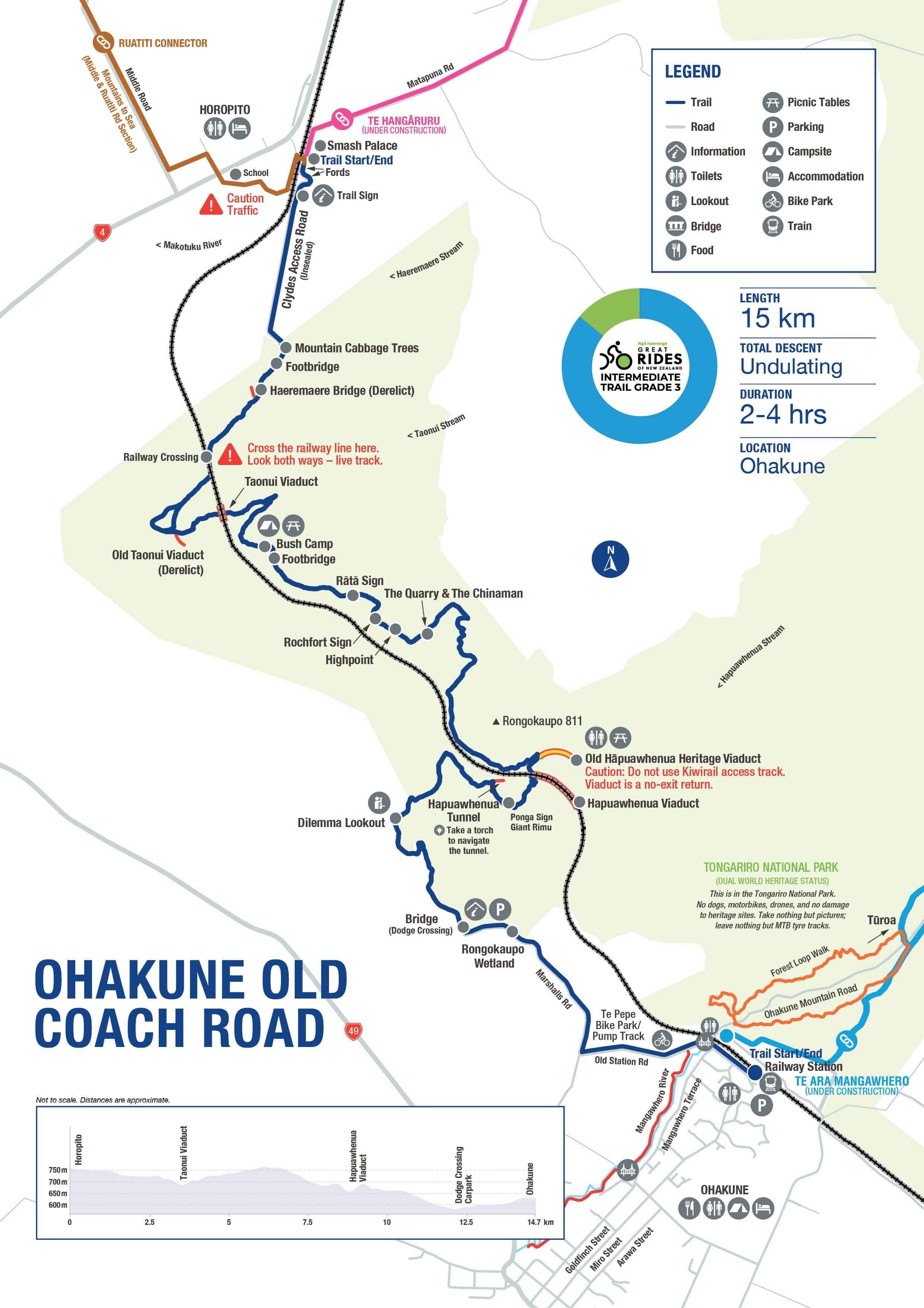
Ohakune Old Coach Road

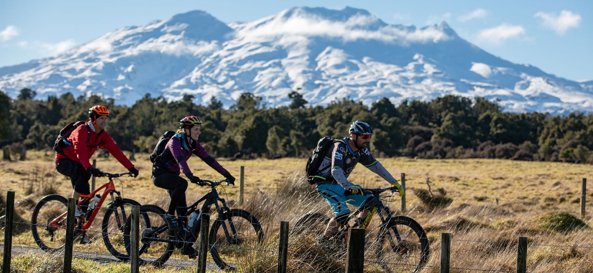
Easily accessible and suitable for riders of most ages and abilities, the trail traverses Tongariro National Park forest and farmland, with many epic lookouts over the volcanic plateau.
Revealed along the way are many surprising and memorable sights – from spooky railway tunnels and grand viaducts, to old bush camps and remnants of the original cobblestone road.
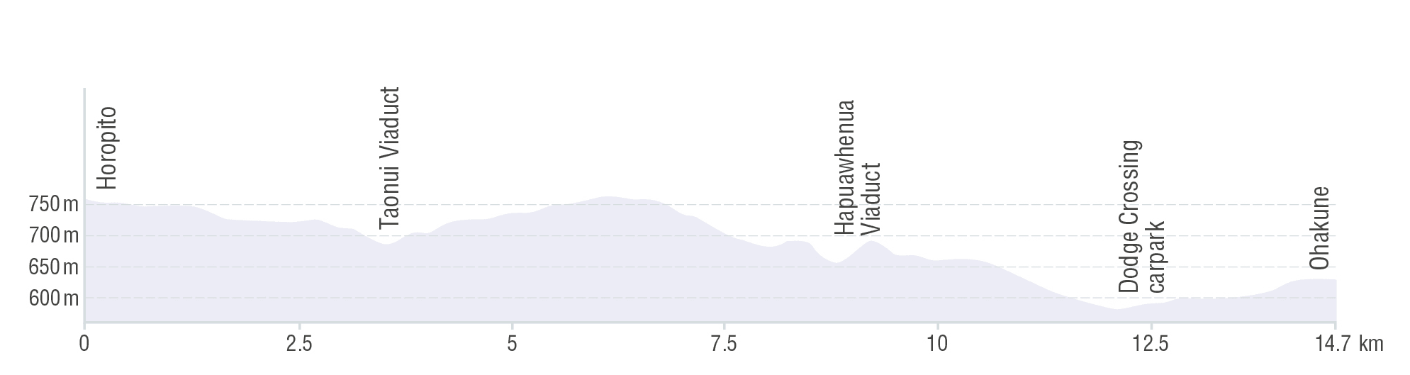
The Ohakune Old Coach Road is great for the whole family and runs between Horopito and Ohakune. Horopito is 170 metres higher altitude than Ohakune, so make the most of the overall descent.
Highlights
- Stunning sub alpine native forest
- Challenging and original cobbled road built of sett stones in the 1880’s
- Panoramic views of Mt Ruapehu, and the surrounding rural plans to the south
- Two historic railway viaducts including the Hāpuawhenua viaduct, one of New Zealand’s oldest and tallest curved viaducts at 45m high and 245m long
- Great information panels connecting today with yesterday


History & Background
The Ohakune Old Coach Road provided an all-weather road link for horse-drawn coaches carrying passengers and goods between the two railheads of the North Island main trunk line. With progress on completing the North Island main trunk rail slow due to the rugged landscape, the road provided a way to allow through traffic, until the railheads were finally linked in 1908.
Trail Route
There are two common ways to ride the Ohakune Old Coach. The easiest is to get shuttled to the Horopito end to make the most of the downhill gradient towards Ohakune.
Reasonable fit riders (or e-bikers) looking for a longer adventure can ride it there and back from Ohakune (around 4–5-hours) – one of the best ways to spend a day around this fascinating part of the Central Plateau.
Local weather
M2SNZ Route Notes:
If you are heading west on the Mountains to Sea – Ngā Ara Tūhono route, then reverse the directions of the trail. Once you have arrived in Horopito, follow the signs that will take you a short distance back down the other side of the line, and around the back of the old Horopito School House to a safe crossing point for SH4 and onto the Middle Road section.
Need to Know
Although this Grade 3 (Intermediate) trail is largely made up of smooth, wide single track (and a section along quiet, country roads), the cobbled sections and some muddy bits make the ride a bit more challenging. In some sections, it may be easier to dismount and walk.
- A mountain or hybrid bike with knobbly tyres is essential. E-bikes are also permitted.
- The trail is well signposted. However, a map will assist you with timing your ride and identifying the many interesting landmarks.
- There is no food and water on the trail, so riders should carry their own supplies. Ohakune is a great place to fuel up, or wind down with post-ride refreshments.
- There is cellphone reception, although it may be patchy in places.
- This is an alpine environment, so the weather can change quickly and it can get cold. Riders should always check the forecast in advance, and take clothing for every eventuality.
- Shuttle transport is readily available but must be booked in advance. Shuttle drivers and other local operators will gladly update you on current track conditions or hazards.
- This section of the Mountains to Sea Trail connects with the Ohakune Mountain Road at Ohakune and Middle & Ruatiti Roads
Need help booking?
Our local i-Site can help you plan and book your trip.
OR Book directly with Trail Partners and discover the Mountains to Sea's cycle trail journeys for yourself.


NGĀ ARA TŪHONO TRUST 50232641
NZBN: 9429052786808