Mangapurua Track - Route details
Trail route is described from Ruatiti Valley. Follow the kilometre markers along the route - these count down from Ruatiti Valley to the Mangapurua Landing
The track climbs steadily for around 6km through private farmland and regenerating native bush, opening up impressive views of Tongariro National Park to the east and the Kaiwhakauka Valley to the north.
At the 10km mark is the junction of the Mangapurua and Kaiwhakauka Tracks. Here a carved tōtara Pou – signifying the spirit of ngahere (the forest) – offers visitors symbolic protection in this special place.
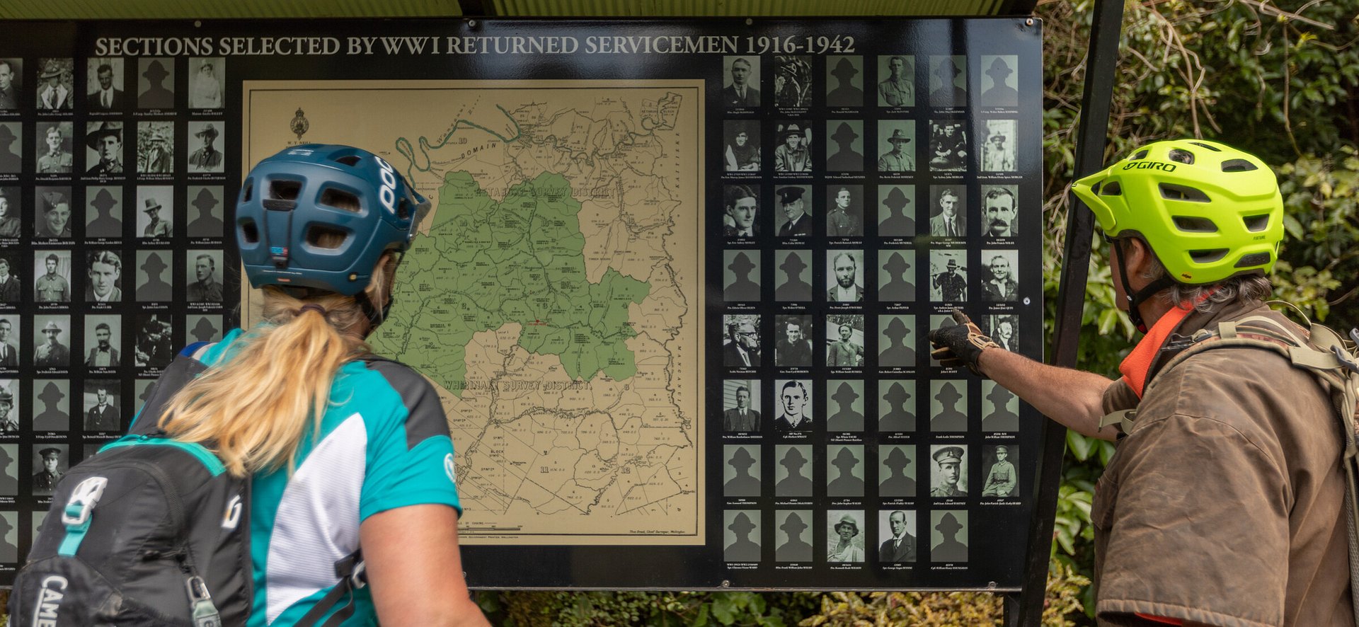
It’s a short climb here to the Mangapurua Trig (12km) from which Whanganui National Park unfolds ahead of you in a series of forested ridges and valleys. Glimpses of Mt Taranaki to the west can be seen on a fine day. At the trig is a memorial to the WWI servicemen and their families who settled the Mangapurua and Kaiwhakauka valleys more than one hundred years ago. From the trig, the track descends steadily to the Bridge to Nowhere.
After crossing Slippery Creek, the track starts to level out before reaching Johnson’s (19km), named after the farmer who collected mail from Mangapurua Landing and distributed it through the valley twice a week. Take a break here or camp overnight.
Continuing down the valley you pass various grassy clearings and papa clay bluffs which are named after the settlers. Their memories live on in wooden signs marking the sites of the original houses and their plantings of exotic trees and shrubs that still flourish here.
The old Bettjeman’s Farm (22.4km) is identified by a straight row of poplars lining the road. The family was one of the first to settle the valley, and some of the last to leave in 1942.
A chimney stack and plants such as holly and cotoneaster are all that’s left of what was once a thriving homestead and bunkhouse which even had its own tennis court. There’s a toilet and a good water source from the stream by the old house site.
A gentle descent takes you to Bartrum’s swing bridge. From here the trail navigates a series of sheer bluffs where riders should dismount as advised by signs. There are also several narrow swing bridges with access steps that require manoeuvring your bike by the back wheel across.
Near Cody’s House, keep an eye out for Current Bun Bluff with its spherical boulders sticking out of the cliff face.
At Waterfall Creek, there’s a 1.5km side-trip up the true left to see the actual cascade. Hellawell’s (27km), once the site of community picnics and hockey games, makes a great spot to linger.
Further along the valley is Battleship Bluff, one of the most striking features along the track. Resembling the prow of an old ship, it presented one of the greatest obstacles to early settlers who spent two years blasting a route across the mighty cliff face. Don’t linger in this papa bluff country and do follow the dismount and walk signs with your bike on the fall hazard side
As you emerge from bush and old homestead clearings the Bridge to Nowhere (32.7km) suddenly appears. It’s an incongruous yet impressive sight arching elegantly across the steep ravine with the Mangapurua Stream 40 metres below. Just beyond the bridge is a lookout track that winds up above the Mangapurua Stream for lofty views of the bridge and surrounding bush.
The final section is mostly board walk. This is a popular day trip walking track: share with care.
The Landing used to be the main supply point for the valley but is now used by canoeists on the Whanganui Journey and jet boat operators running guided trips or collecting riders and bikes for the transfer downriver to Pīpīriki.
Mangapurua Landing—Pīpīriki(32km on the Whanganui river by boat only) Pre-booking a jet boat trip is essential. This 32km river section may also be canoed.The Whanganui River is a highlight of the Mountains to Sea – Ngā Ara Tūhono adventure. It winds through dense forest and a scenic gorge, and bounces over the exciting Ngaporo and Autupu rapids.


Note: During or after significant rain, trail may ride as a Grade 4 with a slippery papa surface.
M2SNZ Route Notes:
Start early so you have plenty of time to stop and explore the abandoned farms along the way without fretting about missing the boat!
Much of the trail surface is papa clay, a dream to ride on when it’s dry. In the wet, however, it has been known to snap derailleurs, destroy brakes and test the mettle of even the hardiest riders. Pick a fine day to ride if possible, and check in with local operators, or our trailstatus page for the latest conditions.
There are a series of small wooden bridges and swing bridges that will require you to be able to lift and manoeuvre your bike across.
This is a remote wilderness ride with few facilities. It is recommended that riders pack well and include a PLB.
Please follow all safety information on the track.
Need help booking?
Our local i-Site can help you plan and book your trip.
OR Book directly with Trail Partners and discover the Mountains to Sea's cycle trail journeys for yourself.


NGĀ ARA TŪHONO TRUST 50232641
NZBN: 9429052786808