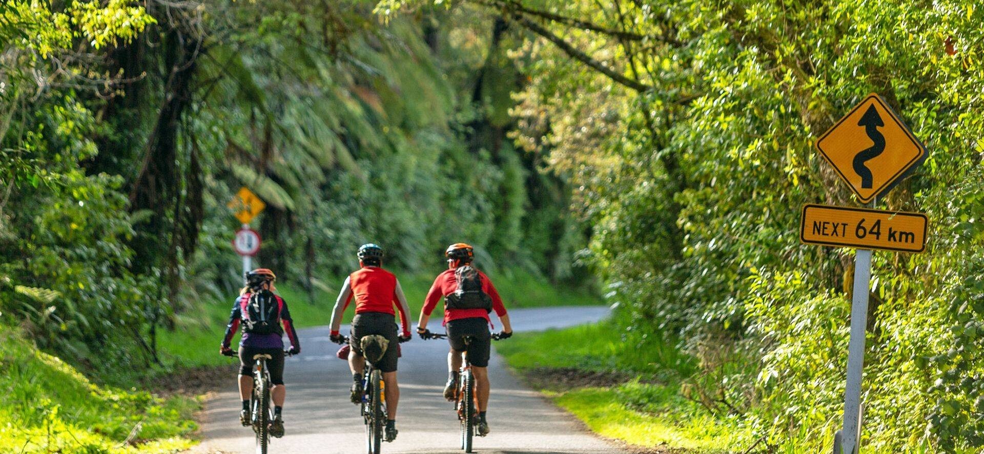
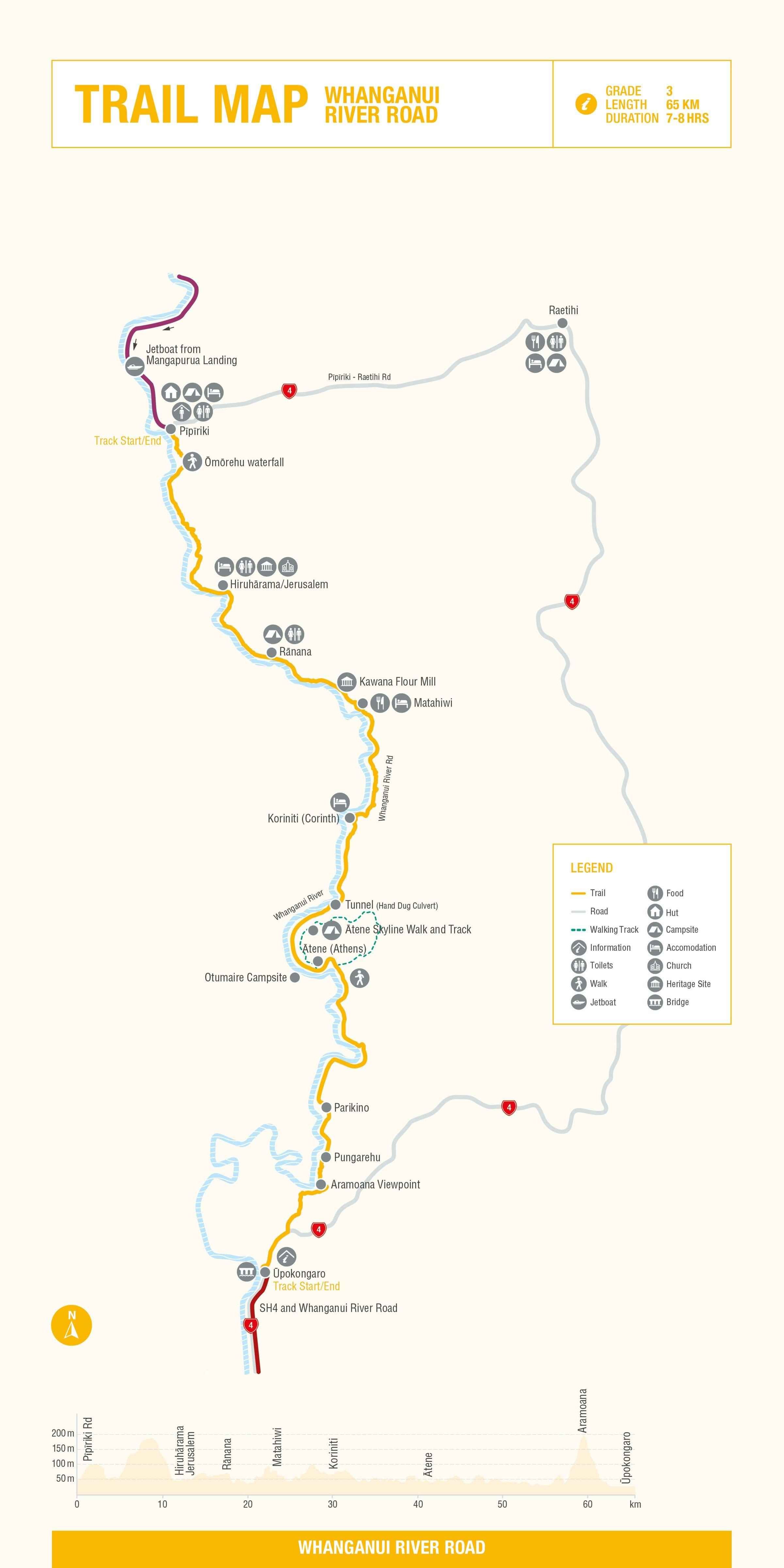
Whanganui River Road
The trail may be ridden in either direction. The trail is described here flowing with the direction of the river towards Whanganui.
Pīpīriki is a gateway to the upper Whanganui River and Whanganui National Park, and the major landing point for canoe and jet boat trips.
Before setting off on the River Road, take time to stop at the large information panel to learn about the history and spiritual and cultural significance of the Whanganui River to tangata whenua (local people). It will help bring the area’s rich Māori and European history to life.
Ōmorēhu Waterfall lookout (5km) is a fine example of the many that cascade into the Whanganui River. An ascent of around 120m – rewards with panoramic views of the river and forested Whanganui National Park. After that it’s all downhill to Hiruhārama/Jerusalem.
Hiruhārama – Jerusalem (9.5km). Home to the century-old St Joseph’s Convent & Church. Check out the church’s beautifully carved alter of Māori design, kowhaiwhai wall panels, and bliss out in the serene rosary garden. Once the home of an orphanage, you can now stay in these authentic surrounds.
The mission’s founder, Mother Suzanne Aubert (1835– 1926) is likely to become New Zealand’s first Saint, with Pope Francis declaring her ‘Venerable’ (an important milestone on the pathway to canonisation) in 2016. Her influence in the Whanganui region is still felt strongly today.
More stories surround another former Hiruhārama resident, the poet James K. Baxter whose commune closed soon after his death in 1972.
Moutoa – a small river island (17km) can be seen from the road. This was the scene of a short and fierce battle in 1864. This helped establish a close bond between local iwi and European settlers.
Rānana, aka London (19km). One of the larger settlements along the River Road, it is home to an historic catholic church, a school, and a beautiful marae – one of many that can be seen from the road. Nestled beside the river past the marae is a pleasant campsite (with toilets).
Kawana Flour mills was constructed in 1854. It is now a living museum with a rebuilt water-powered mill featuring the original waterwheel and grinding stones, and a restored miller’s colonial-style cottage. The mill was an early
Māori ‘think big’ project. Many Māori embraced the new opportunities offered by the international economy. It is the last remaining flour mill on the Whanganui River and the only remaining 1850s mill machinery in New Zealand
Matahiwi (22.8km) is the hub of a small farming community. The schoolhouse was transported here by riverboat from Parinui (46km upriver) in 1923 and is now the Matahiwi Gallery Café– an excellent place to stop for coffee and home-baked goodies. This is the only refreshment stop on the River Road and also offers accommodation options.
Follow the undulating road for 7km to Koriniti, a stunning example of a small local marae featuring two traditional wharenui (Poutama and Te Waiherehere) as well as a small museum. This is a popular stop for cultural tours and overnight stays, which must be booked in advance. A further 500m downstream is the some truly unique accommodation, The Flying Fox reached via an aerial cable across the river.
Enjoy the downhill and flat section for the next few kilometres as you head to river level.
Otumaire campsite (40.5km) is a basic DOC campsite.
Downes Hut (42.1km) – a small historic structure built in the 1920’s on the opposite side of the river by Thomas
D. Downes, the original River Foreman. Bequethed to the Whanganui River Trust Board, it is now cared for by the Department of Conservation and used by canoeists other recreational groups. The hut is built on a former kāinga (settlement) site known as Pukupuku. A magnificent puriri tree planted by Downes still flourishes.
Ātene Skyline Walk (42.5km) (Full walk is 6-8-hour tramp) lies within a non-contiguous part of the Whanganui National Park. The track rises to a height of 572m and offers outstanding views over the region and a cut-off section of the Whanganui River known as a meander. A shorter option (2 hours return) is the Ātene Viewpoint Walk that takes in the first section of the Skyline Walk.
Ātene /Athens (43km) was named after the Greek capital by the missionary Reverend Richard Taylor. Look out for the small meeting house, constructed in 1886.
Keep an eye out for the shell rock Cliffs (50.5km). The layers of fossilised oyster shells in the cliff face are an evidence of the Whanganui region’s past when it used to be submerged under the ocean.
Two old pā (fortified village) sites – Parikino (53km) and Pungarehu (56km) – complete the undulating sections. The original Parikino site was located on the other side of the river, but, as with many of the pā and marae, the opening of the river road saw a gradual shift to the river’s true left. Prior to the 1930s almost all access to these remote settlements was from boats operating along the Whanganui River.
Aramoana Hill (59km), also known as ‘Gentle Annie’, is the toughest climb on the road. It’s steep and long but rewards you with a fantastic vista of the river valley, Pungarehu and Mt Ruapehu.
The descent down the other side takes you to the information point at the junction of Whanganui River Road and State Highway 4.
Take care crossing this junction and head right.
Upokongaro (65km), has a dedicated cycling bridge stretching over the Whanganui River, that the small village to the historic and arty city of Whanganui just 12km downstream. Upokongaro used to be an important ferry crossing and riverboat stop, today it’s a great place to stop for refreshments.


Need to Know
This Grade 3 (intermediate) trail will suit riders of most ability, although a decent level of fitness is required to complete the ride in one day.
- The trail follows the fully sealed (tarmac) Whanganui River Road for its entire 64km length, plus a 3km section on State Highway (SH4) between the southern end of the River Road and Ūpokongaro.
- Despite following the Whanganui River as it gently meanders downstream, the road is undulating with over 600m of climbing in total. The two ‘best’ climbs are in the first and last 10km of the ride.
- Traffic on the River Road is generally light but it can get busy during the summer months; good road sense is required.
- Heavy trucks and cars barrel along the short state highway section so riders should take extra care here. Hi-vis clothing is recommended.
- Mountain bikes, hybrids, tourers and even road bikes are suitable (although the road is a bit lump in places). E-bikes are also an option provided they have the capacity to last for the whole day in this hilly environment.
- Unless you somehow accidentally head west along Raetihi Rd at the start, it’s pretty much impossible to get lost. Just keep the river on your right-hand side! A map and a copy of the Whanganui River Road Guide, will help you time your ride and appreciate the fascinating stories of this special place.
- The road can be ridden all year round, although the best weather is generally between November and April. Heavy rain can occur at any time of year, and if a southerly is blowing it can be a very long day in the saddle. Check in with the locals for the latest weather forecast and road conditions.
- The Pīpīriki campground has a tiny shop that sells basic supplies, soft drinks and ice cream, although riders should bring plenty of food. If it open when you pass, the Matahiwi Gallery Cafe is definitely worth a stop even if you consider yourself well stocked. (Who can resist home baking?)
- Tap water is available at reasonably regular intervals along the road. The cafe and hotel in Ūpokongaro or one of the many restaurants, cafes and bars in Whanganui are great places to wind down and reflect on this fascinating journey.
- Cellphone reception along the Whanganui River Road is patchy at best, and cannot be replied upon.
- Shuttle transport is readily available but must be booked in advance. Many of the operators also offer packages combined with the jet boat ride down the Whanganui from the end of the Mangapurua Track to Pīpīriki. There are operators based in National Park, Ohakune, Raetihi and Whanganui, and a couple of outfits with bases in Pīpīriki.
- Shuttle drivers and other local operators will gladly update you on current road conditions or hazards.
- There are toilets in Pīpīriki, the convent at Jerusalem, Rānana, Kawana Mill, Matahiwi Gallery and the Otumaire campsite.
This section connects with the Mangapurua Track, and Ūpokongaro to Tasman Sea
Need help booking?
Our local i-Site can help you plan and book your trip.
OR Book directly with Trail Partners and discover the Mountains to Sea's cycle trail journeys for yourself.


NGĀ ARA TŪHONO TRUST 50232641
NZBN: 9429052786808