Kaiwhakauka - Trail Notes

Advanced riding especially in wet conditions | Check status
Part of this trail is a converted tramping track and there is a small section (approximately 4km) that is narrow single track with some drop offs. If you are not confident – we recommend taking your time and walking these sections – enjoying the bush. (There are plans to improve this area, but it will always be a remote adventure).
Trail Route
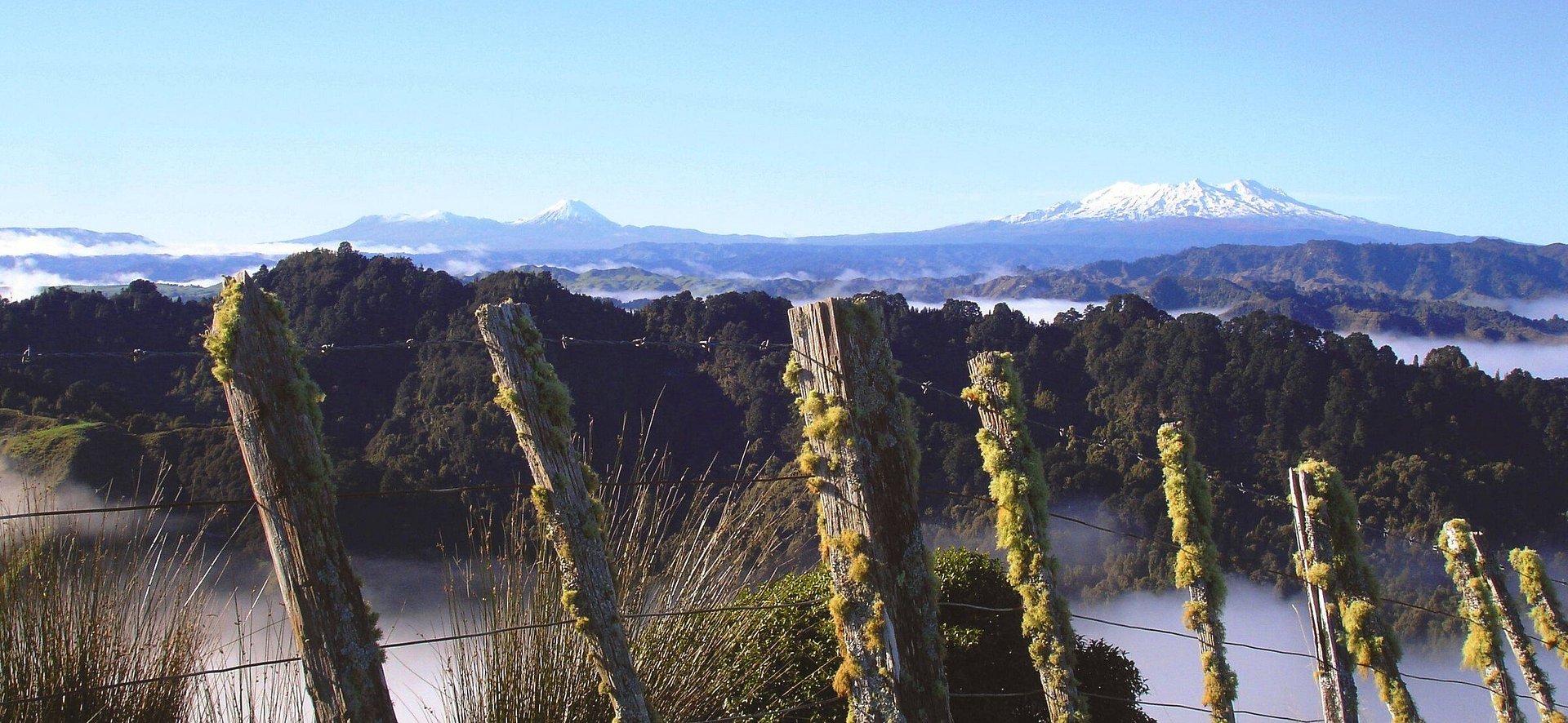
Exceptionally beautiful, boasting hidden creeks, lush bush, and pretty farmland, and rustic relics of a bygone era. The fact that few people venture here adds a feeling of intrepid adventure. The Kaiwhakauka is a true back country trail best suited to fit, experienced, and well-equipped mountain bikers with no fear of sweat and mud. Much of it is narrow, technical single-track that can get very muddy after rain.
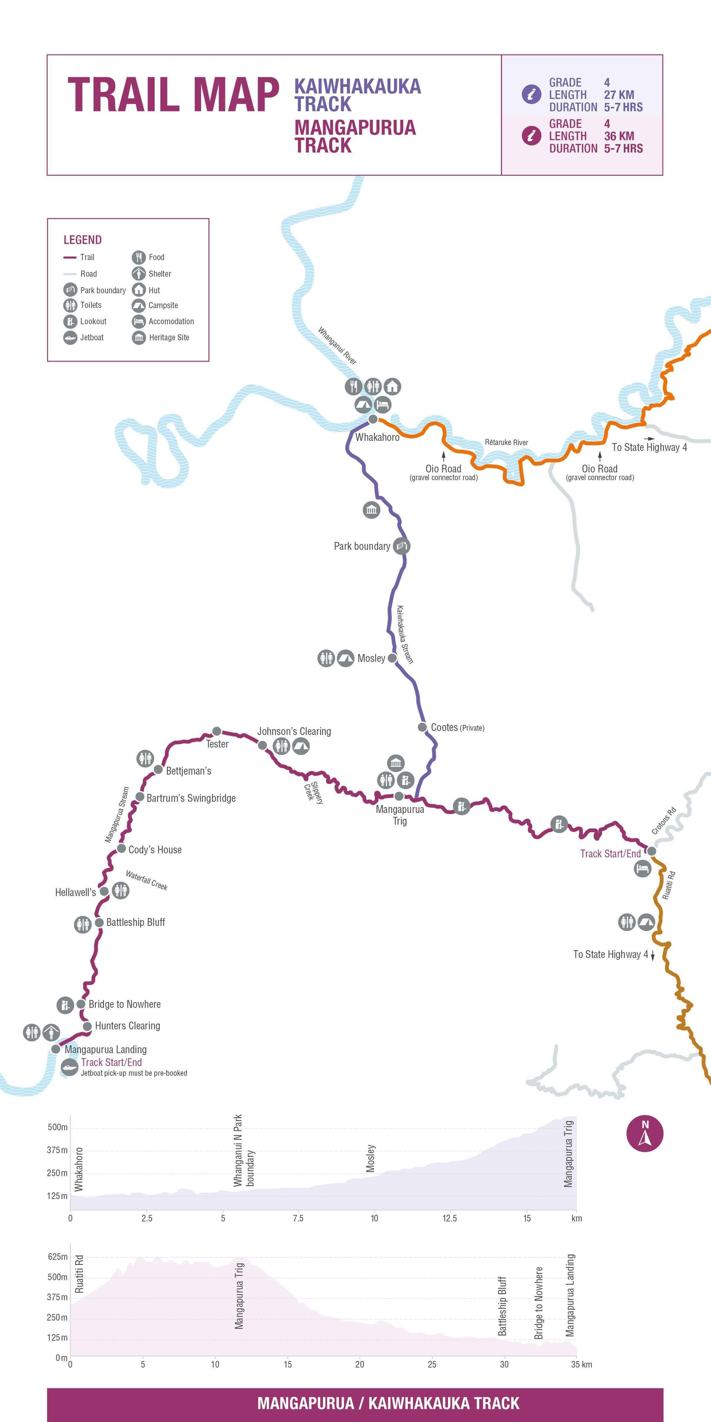
The trail starts at Blue Duck Station at Whakahoro, on the banks of the Whanganui River, 45km west of SH4 near Owhango. The station is a working farm, so named for the resident whio (blue ducks). The Blue Duck Station team put considerable work into conservation, particularly Whio
and Kiwi. They also offer authentic, homespun hospitality in both food and lodging. It is a great spot to recharge before heading out on the Kaiwhakauka.
Follow the (sometimes muddy) gravel road up towards the Whanganui National Park entrance. Along the way take a few minutes to climb down the short walking track to admire the waterfall that cascades into a canyon that is also home to glow worms, whio and more.
Just before heading into the bush take time to explore the “Depot”. A historical stone floored building filled with remnants of the past, used to store deliveries from the riverboats for the settlers of the area.
Through the gate, the track leads up the valley through a mixture of regenerating bush and farmland to the Whanganui National Park boundary.
From the park boundary its primarily single track with some steep drops to the river – walk if you need to. Eventually you come to the old Mosley homestead site near the Waione Stream. The open clearing here lends itself well to camping (there is a shelter here).
The track continues towards Cootes’ homestead (private land), crossing many small, bridged side streams with only a few small open flats. The old Tobin homestead, which is marked by an old chimney stack, can be seen to the right of the track.
From here there is a steady climb of 3.2km of a mostly clay farm road through relatively undisturbed mixed tawa/ podocarp forest to the junction marked by a carved tōtara pou on the old Kaiwhakauka and Mangapurua roads. The pou symbolises the ngahere (forest) and provides spiritual and cultural safety for visitors. The pou also pays tribute to the settlers of the Mangapurua and Kaiwhakauka Valleys


Distances
Whakahoro to the Pou junction is 27km. The combined distance to Mangapurua landing is 41kms. The jet boat pick-up must be booked in advance (see Mangapurua notes.)
An alternative connection (especially in Winter) is to turn left at the Pou and ride down towards the Ruatiti Valley
Need to Know
The Mangapurua Track is made up of remote, rough-and-ready 4WD track and backcountry singletrack, much of which is on papa clay – smooth, fast and flowing when dry, but super-slippery in the wet. The majority of the riding is not especially technical but there are steep drop-offs to the side in some places
The track also sidles around a series of bluffs with precipitous drop-offs and rock-fall hazards. Riders should take extra care on these sections, as signposted.
These factors makes it a Grade 4 (advanced trail best suited to experienced mountain bikers, rain or shine.
Please be aware, after rain or severe weather condition of the Mangapurua track may change. At any stage, there may be fresh debris or windfalls on the track, particularly around the papa bluff sections. After significant rain, please check the track status updates on this site: the chance of a new slip or windfall is high.- The Managapurua track is open on a seasonal basis only, (Winter closure).
- The track may also close temporarily for inspection after heavy weather events : Please do check the Track status for current conditions. The team at Department of Conservation are committed to providing a safe and enjoyable track, and work hard to maintain this remote section - and we thank them.
- Consider riding Mangapurua only if you have sound riding skills and are prepared to ride with due care. The Whanganui national park is is a remote, dynamic terrain and environment, hence the track requires respect at all times as conditions may change unexpectedly.
- As you cycle through the trail, if you do encounter any section you have doubts about your ability to cross, then please walk. (these sections are generally very short). It is recommended you position your bike on the outside edge of any fall hazard (bluffs or drop offs), this is the safest and most balanced way to cross narrow sections.
- E-bikers and those with panniers — be aware you may be required to lift/carry your bike around debris
- There is no mobile coverage, you are advised to take basic tools and safety gear, including a PLB
- A good-quality, well-maintained mountain bike is essential. Decent bike mechanical skills are a must as it’s a long way from help.
- Mountains to Sea markers line the trail at regular intervals and track junctions are clearly signposted. A map and/or DOC’s Mangapurua/Kaiwhakauka Tracks brochure, however, will help time your ride and identify the many interesting landmarks.
- The best time to ride the track is between November and April when the weather is most settled. However, heavy rain can occur at any time of year in Whanganui National Park and track conditions can change quickly. Riders should therefore be prepared for every eventuality.
- Be sure to check the weather forecast, and pick a fine day to ride if at all possible. DOC, tour operators and local visitor centres can advise on various expectations including current track conditions.
- This is a wilderness ride with no shops or services. Riders should take plenty of food and water, although there are places to fill water bottles along the way. Very basic supplies including ice creams and drinks are available at the campground in Pīpīriki.
- There is virtually no cellphone reception on the track. Riders should consider carrying a PLB (personal locator beacon) or ‘spot tracker’.
- All shuttle and jet boat transport must be booked in advance.
- Local tour operators offer a variety of packages including two and three-day adventures with accommodation.
- Public toilets are located at the start of the track and regular intervals along the way at the Mangapurua Trig, Johnson’s, Bettjeman’s, Hellawell’s and just after the Bridge to Nowhere.
- This is Section 4 of the Mountains to Sea Trail, connecting with the Middle & Ruatiti Roads (Section 3), and Whanganui River Road (Section 5) at Pīpīriki.
Need help booking?
Our local i-Site can help you plan and book your trip.
OR Book directly with Trail Partners and discover the Mountains to Sea's cycle trail journeys for yourself.


NGĀ ARA TŪHONO TRUST 50232641
NZBN: 9429052786808